Background
A successfull collaboration
The desire for a single, shared coastline used by both Lantmäteriet and the Swedish Maritime Administration (SMA) has existed for quite some time. In 1996, an agreement for routines and collaboration was written which said that:
- Both agencies would produce and manage a shared, original version of Sweden’s shorelines and associated categories.
- Both agencies would have a shared responsibility for gathering, updating and managing data. Lantmäteriet would contribute shorelines and islands larger than 25 m2 and SMA would contribute smaller objects such as above-water rocks, water-swept rocks, smaller islands, wharves, piers, etc. within their charted areas.
- Lantmäteriet would be responsible for warehousing the shared version of Sweden’s shoreline.
- The grounding principles of the agreement would be complemented by detailed specifications, and practical routines for collaboration would be established.
With this collaboration agreement as a base, a pilot study project was conducted in 2002 to investigate the possibilities for a shared NSL by Lantmäteriet and SMA.
During this pilot project, the newly mapped shoreline in GGD (Grundläggande Geografiska Data, Lantmäteriet’s main database) was compared with the shoreline in SMA’s nautical chart database, SJKBAS, as well as with orthophotos.
Using this comparison, the study concluded that the natural shoreline found in GGD was of good quality. The natural shoreline was qualified as shoreline not containing constructions such as wharves, piers, etc. The pilot project also concluded that SJKBAS contained good-quality data within harbors. New mapping of NSL would therefore use the best quality data from GGD’s natural shorelines and the SJKBAS as a reference point.
The pilot project also determined that NSL should contain the following categories: shoreline, rock awash, above-water rock, smaller islands, wharves, piers, breakwaters and dolphins. To achieve this, the mapping of smaller islands, rocks awash, etc had to be carried out.

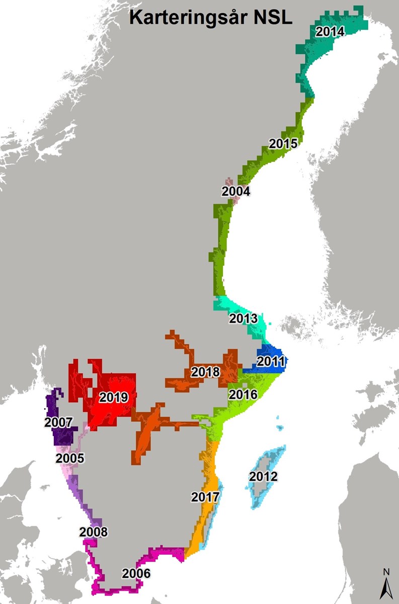
- 2003-2004: project started with aim to write specifications, come up with technical solutions, management plans, etc. Chart 523 (from Härnösand-Kramfors) chosen as pilot area.
- 2005: NSL production in Göta Älv.
- 2006: NSL production in Skåne and Blekinge, from Öresund to Karlskrona and as well as Vänersborg. Information about NSL published on SMAs website.
- 2007: NSL production in Western Götaland, from Wallhamn to Strömstad.
- 2008: NSL production in Halland County. Horizontal reference system changed from RT90 to Sweref 99 TM and gridding system for geographic division of Sweden also changed in specification.
- 2009-2010: no new production of NSL.
- 2011: NSL production in northern Stockholm, in the Furusund fairway area. Change of vertical reference system from RH70 to RH2000.
- 2012: NSL production in Gotland.
- 2012-2013: NSL production within the sea borders project, encompassing an approximately 1 km broad zone around the entire coast containing the existing baseline points for Sweden’s borders.
- 2013: NSL production of the Uppland coastline, from Gävle-Furusund.
- 2014: NSL production of Bottenviken, Haparanda-Skellefteå. Object class BOM_M added to the NSL Specification.
- 2015: NSL production in Bottenhavet, from Skellefteå-Gävle
- 2016: NSL production from southern Stockholm to Norrköping.
- 2017: NSL production from Valdemarsvik to eastern Blekinge and the western side of Öland.
- 2018: NSL production of Hjälmaren, Mälaren, Vättern and Göta Canal.
- 2019: NSL production of Vänern, Dalslands Canal and Säffle Canal.
- Biannual updates starting 2019.
Last updated 2021-06-09