Communication
VHF communication between mariners and VTS Gothenburg.
VTS Gothenburg
VTS Gothenburg - VHF Ch 13 - is in charge of traffic information in the area from Tistlarna in south to Hälsö in north.
Reporting is compulsory for
- Vessels exceeding 300 GRT.
- All vessels, inclucing tows, of over 45 metres in length.
- Fishing vessels in commercial operation irrespective of size.
Information service
The VTS informs concerned vessels about the occurrence of other vessels in the fairway and other relevant information which will have influence on safe naviation in the traffic area.
All vessels attending the reporting system shall continuously listen on VHF channel 13 and 16.
Vessels shall report to the VTS as follows
When entering a VTS area or before leaving berth/anchorage area:
Vessel's Name (A),
Call Sign (A),
Closest name of reporting line or Geographical location (C or D),
Intended Route (L),
Destination (I), and
Draught (O).
A vessel may not depart from berth or anchorage in the Göteborg VTS Area without having first received VTS permission.
When passing stated reporting points, (in the direction of the arrow in the charts):
Vessel's Name (A),
Reporting Point, and
Destination (I).
The following information must be submitted to the VTS Centre when change of intended route is made:
Vessel's Name (A),
Position (C or D),
New Intended Route (L), and
Destination (I).
The following information must be submitted to the VTS Centre upon arrival at the berth or at anchorage:
Vessel's Name (A),
Position (C or D).
The following information must be submitted to the VTS Centre at fault, or damage to machinery, equipment or instruments that are substantially likely to impair the ship's safe navigation and maneuvering:
Vessel's Name (A),
Position (C or D)
Destination
The failure or damage which is the reason for reporting (Q).
On request from the VTS centre, vessel shall:
- provide information to the VTS centre even at times other than those mentioned above, and
- supplement the notification with additional details if needed so ship traffic will be able to move safely and efficiently in the VTS area.
Reporting of accidents and incidents
Upon marine casualty, JRCC shall be alerted immediately (call "Sweden Rescue"). In addition, the VTS centre should be promptly informed, in the event of or observed grounding, collision, incident, accident or other factors affecting the safety and accessibility in the fairway.
Use of AIS
The captain is required to ensure that the static, dynamic, and travel related information in the ship's AIS is always correct in accordance with IMO Res. A.917 (22), Res.A.956 (23) and UFS snippets No 1963 (incl. appendix) and No. 2328th.
VHF
Ships in the VTS area shall always keep watch on applicable VHF channel.
Other traffic
Vessels not covered by the mandatory reporting system, and has a VHF radio, should keep continuous watch on applicable traffic channel when engaged in the traffic area. The notification referred to above should be made if circumstances make it appropriate.

VTS Area Gothenburg
Call: VTS Gothenburg (VHF Ch 13)
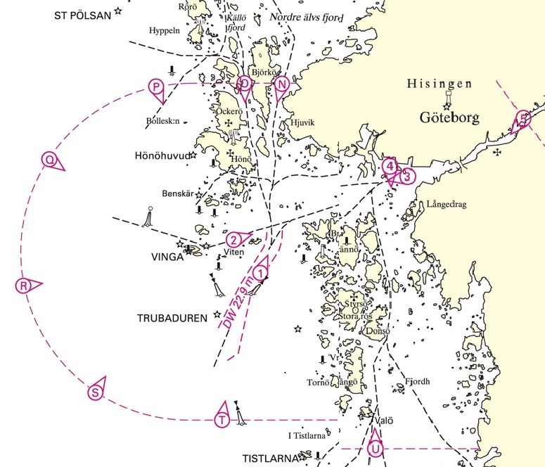
VTS Area Gothenburg is the water area at and outside Gothenburg and bounded by a line extending
a) in the west by an arc at a distance of 6 M with the center in Vinga Lighthouse at position 57°37.92 'N 11° 36.08' E
b) in the north by the latitude parallel 57°43,9'N tangential the circular arc towards land,
c) in the south by latitude parallel 57°31,9'N tangential the circular arc towards land, and
d) in the east, across Göta älv, 57°45,81'N 12°00,07'E
Reporting lines for the VTS Area Gothenburg
| Reporting name | Geographical position | Geographical location |
| Reporting Line N | app. 57°43,9'N 11°42,3'E | (area border east of Björkö) |
| Reporting Line O | app. 57°43,9'N 11°39,8'E | (area border west of Björkö) |
| Reporting Line P | app. 57°43,8'N 11°33,9'E | (Sector area border on circular arc) |
| Reporting Line Q | app. 57°41,2'N 11°26,8'E | (Sector area border on circular arc) |
| Reporting Line R | app. 57°36,7'N 11°25,1'E | (Sector area border on circular arc) |
| Reporting Line S | app. 57°32,9'N 11°29,9'E | (Sector area border on circular arc) |
| Reporting Line T | app. 57°31,9'N 11°38,3'E | (Sector area border on circular arc) |
| Reporting Line U | app. 57°31,9'N 11°48,4'E | (area border east of Tistlarna) |
Reporting points in the VTS Area Gothenburg
| Reporting name | Geographical position | Geographical location |
| Reporting point # 1 | app. 57°37,17'N 11°40,85'E | (at Buskärs Knöte) |
| Reporting point # 2 | app. 57°38,34'N 11°39,09'E | (north Vinga) |
| Reporting point # 3 | app. 57°40,99'N 11°50,51'E | (at Älvsborg fortress) |
| Reporting point # 4 | app. 57°41,34'N 11°49,36'E | (at Arendal) |
| Reporting point # 5 | app. 57°42,20'N 11°56,86'E | (at Stena Line Terminal) |
| Reporting point # 6 | app. 57°43,34'N 11°59,26'E | (Tingstads tunnel) |
| Reporting point # 7 | app. 57°43,88'N 11°59,71'E | (north Marieholmsbron) |
| Reporting point # 9 | app. 57°45,82'N 12°00,08'E | (the mouth of Lärjeån) |
Geographical names
Following geographical names are frequently used during VHF communication between the VTS and mariners in the area:
Last updated 2021-01-29